
TatukGIS Developer Kernel for .NET is a powerful and flexible .NET library for creating custom Geographic Information System (GIS) applications or adding advanced geospatial capabilities to existing software. A large number of GIS functionality containing over 750 classes and 19,000 documented methods and properties are provided by an easy-to-use, object-oriented API. Developed natively (in other words compiled) for .NET, the library is consistent with other platform editions, including Delphi, Java, and Python, making it easy to switch to or migrate across technologies.
The DK can support a huge range of geospatial data formats directly for more than 70 data formats natively and many more through other drivers. It integrates seamlessly into advanced spatial databases such as PostGIS, Oracle Spatial, and Microsoft SQL Spatial and even into BIM (Building Information Modeling) through the IFC format. Data is accessed directly without the conversions to proprietary formats and with performance and simplicity.
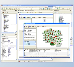
The TatukGIS Developer Kernel for .NET helps ease up mapping and spatial analysis, data processing with its feature-rich toolkit. Besides, it features more advanced features such as hydrology analysis, 3D visualization, geocoding, and slope calculation. For developers wishing to build GIS applications in the professional grade, the DK is the perfect choice for creating desktop, web, and mobile applications.
Key Features of TatukGIS Developer Kernel for .NET :
- Extensive Data Format Support - Supports 70+ native formats, advanced spatial databases, and direct data access without conversion.
- Flexible Mapping Tools - Offers on-the-fly reprojection, 5,000+ coordinate systems, thematic mapping, and SVG map symbols.
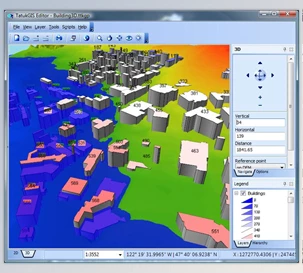
- 3D Visualization - Enables realistic 3D representation of geospatial data.
- Spatial Analysis - Includes tools for slope analysis, viewshed visibility, grid interpolation, and hydrology.
- Vector Editing - Provides advanced tools for creating and modifying vector layers.
- Raster Algebra - Allows complex raster operations and calculations.
- Geocoding - Supports address geocoding and reverse geocoding.
- GPS Integration - Real-time GPS tracking and routing support.
- Topological Operations - Facilitates advanced spatial relationship analysis and workflows.
- Cross-Platform Consistency - Unified API ensures easy migration between .NET, Delphi, Java, and Python editions.
Click on the links below to Download the latest version of TatukGIS Developer Kernel for .NET with CRACK!
 TatukGIS Developer Kernel for .NET v97.0.36417 (30 Dec 2024) ENTERPRISE + CRACK.rar (Size: 126.2 MB - Date: 11/26/2025 8:35:42 PM)
- TatukGIS Developer Kernel for .NET v11.81.0.32618 (01 Sep 2023) ENTERPRISE + CRACK.rar (Size: 115.2 MB - Date: 11/26/2025 8:35:40 PM)
- TatukGIS Developer Kernel for .NET v11.77.0.31755 (29 Apr 2023) ENTERPRISE + CRACK.rar (Size: 115.7 MB - Date: 11/26/2025 8:35:37 PM)
- TatukGIS Developer Kernel for .NET v11.74.1.30997 (30 Jan 2023) ENTERPRISE + CRACK.rar (Size: 115.2 MB - Date: 11/26/2025 8:35:35 PM)
Files Password : DownloadDevTools.ir
Note
Download speed is limited, for download with higher speed (2X) please register on the site and for download with MAXIMUM speed please join to our VIP plans.
Discover free tools, limited-time offers, and stay updated with the latest software we release.

![FREE Download DevExpress Universal Complete [.Net Components] v26.1.3.26179 (18 Jun 2026) + Documentation + Patcher](https://downloaddevtools.com/filemanagercontent/files/1/prolistnormal/124-banner.png)


2/26/2025 11:43:53 AM
Is true software? How to ensure this software works after registering for VIP account. Previously bought cracked software and could not use. Does this software contain virus?
Thank you for your comment, this product has been cracked by our team and we can guarantee it, it has been tested and working in full function mode.
2/24/2025 5:24:44 PM
Is true software? How to ensure this software works after registering for VIP account. Previously bought cracked software and could not use. Does this software contain virus?